info@pelicangeographics.com
+44 (0)1730 302039

Datamine Discover 3D
Datamine Discover 3D
Bringing even greater insight to your data
In July 2017, Datamine acquired the Encom Discover suite from Pitney Bowes.
Datamine Discover 3D is a world class combination of MapInfo Pro and Discover 3D.

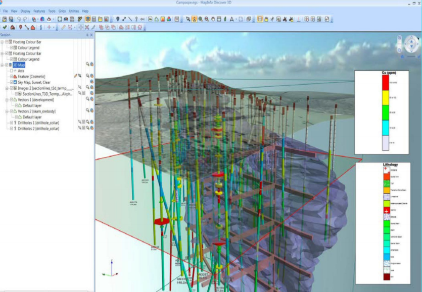
Discover 3D works in conjunction with Discover 2D providing a seamless link from traditional 2D into 3D GIS.
Discover is designed to meet the needs of geologists, environmental scientists, cartographers, exploration managers, and petroleum engineers.
Share your Discover 3D environments using the free Discover Viewer, where users can visualise and fully interact with any pre-created Discover 3D session.


Key Facts
- Datamine Discover3D is available as an add-on for your existing Discover 2D, or as a full product including Discover 2D and MapInfo Professional
- No separate MapInfo or Discover 2D licence is required
- If you have a separate MapInfo and Discover3D licence, we can upgrade you to the combined installer. Please contact us with your serial numbers and company details.
Current Release
- v2017 was released as a MapInfo-Discover2D "bundle" in November 2017, and is only available in 64-bit.
- If you are using a 32-bit computer, MapInfo-Discover3D v2015 can still be used. Please contact us for downloads.
- View a MapInfo-Discover3D datasheet here
Older versions
- MapInfo-Discover3D v2015, released in 2015, is a 32-bit product. There will be no further updates or upgrades of the 32-bit release from October 2016.
- Discover3D 64-bit was first released with v2015.2 in Q3 2015.
- Discover3D 32-bit and 64-bit can both be installed on the same machine. They will share the same serial number.
- Contact us now for information about how to upgrade to the latest release.
- Older versions can still be downloaded. Visit Datamine's download site or contact us for more information.
Supported Operating Systems (64-bit)
Windows® 10 & Windows® 11
Supported Databases:
XY - i.e. Databases that store point data as X & Y numeric columns:
Microsoft Office 2016, 2019, 2021, 365
Spatial - Databases that store map data as objects including: points lines and regions
Microsoft SQL Server 2012 (also called SQL Server Spatial)
Oracle Spatial 11Gr2, 12cR1
PostgreSQL 9.0.3 with PostGIS 1.5
PostgreSQL 9x with PostGIS 2.1x
FDO 3.8
Database Connectivity:
Microsoft SQL Server 2012
Microsoft Access ODBC and other ODBC-compliant databases
OGC GeoPackage
PostGIS
Oracle
SQLite
Minimum Hardware Specifications
Core i3/i5/i7 6000+ series or equivalent CPU processor with AVX extensions (note MapInfo/Discover does not utilise multiple CPU cores in most tools.)
4 Gigabytes of RAM memory
A monitor of at least SD (1366 x 768 resolution)
5GB Disk space on the Windows installation drive
Recommended Hardware Specifications
Core i5/i7 7000+ series CPU processor with AVX extensions (note Xeons are not faster and MapInfo/Discover does not utilise multiple CPU cores in most tools.)
8 Gigabytes of RAM memory
Dedicated NVIDIA or AMD Graphics Card with at least 512MB dedicated memory (VRAM).
Multiple Full HD (1920 x 1080) monitors or a high resolution single monitor (note 4K monitors have some known compatibility issues with 3rd party software and Mapinfo Pro)
5GB Disk space on the Windows installation drive
Info
info@pelicangeographics.com
Phone: +44 (0)1730 302039